Basic HTML Version


The River Thames bubbles up from a spring in the low
limestone hills of the Gloucestershire Cotswolds, the
precise location of which, despite the incredible know
how of geologists and geographers and other men and
women of science is still disputed. Some say Seven
Springs to the north of Cirencester in the Churn
Valley (which is marked as the source on our earliest
important map The Gough Map kept at the Bodleian
Library in Oxford) but most say the source is a sleepy
sort of spring called Thames Head by an ancient ash
in a field called Trewsbury Mead about three miles
South-West of Cirencester. Nowadays topographical
pilgrims seeking the source of the Mighty Thames
must make do with an underwhelming scattering of
stones in a dusty dip in a field and a roughly hewn
stone that has all the promise of an ancient monolith
but all the disappointment of a much more recent
inscription:
'The conservation of the River Thames 1857-1974.
This stone was placed here to mark the source of the
River Thames.'
The best you can hope for is a seep! After heavy rain
the stones are submerged in a shallow pool of clear
water broken by the occasional bubble as the Thames
Head spring breaks the surface 356 feet above sea
level and trickles down the slope of the meadow to
begin its 215 mile journey through nine English
counties to the North Sea. Mostly though it’s not
until about a mile from the source when the Lyd Well
at Kemble pumps a bit of life into the Thames that
you’ll actually see anything wet let alone river-like.
But gradually the river volume will build and that
drop of 356 feet, the equivalent of a building with
35 floors, from the source to the sea is why we need
locks and weirs on the non-tidal Thames to manage
flooding and maintain depths for navigation by boats.
About ten miles from Thames Head is Cricklade, the
only Wiltshire town on the Thames. The name means
place by the river crossing and here for the first time
with the addition of water from the River Churn there
is sufficient depth of water in the nascent Thames for
small craft but it’s not much more than a foot deep
although it was once deep enough for barges to arrive
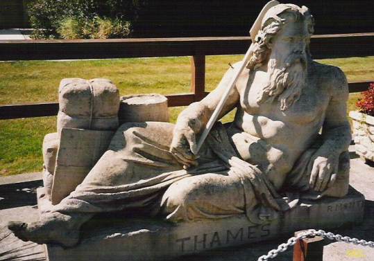
here from London. Today the official start of the
navigable Thames is St John’s Lock just above
Lechlade, (where lounges Old Father Thames, above)
the first of 45 locks and weirs that divide the River
Thames into 44 narrow lakes known as Thames
Reaches. The last lock before the start of the tidal
River Thames is Teddington – Tide End Town.
Going With The Stream: Thames Head to Windsor